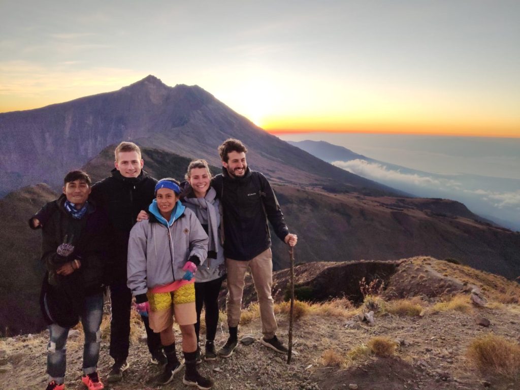
Rinjani’s best-kept secret — the uncrowded southern route through pristine rainforest, savanna, and the summit of Mount Sangkareang.
⏱️ 2 Days / 1 Night
Duration |
|
📏 3,200 m
Max Altitude |
|
🟡 Moderate – Challenging
Difficulty |
|
📍 Tetebatu → Tetebatu
Start → End |
🌿 Why the Tetebatu Route?
Most trekkers start from Senaru or Sembalun — but the southern Tetebatu route is Rinjani’s hidden gem. Starting from our home village at the foot of the mountain, this trail winds through miles of untouched tropical rainforest, across rolling savanna ridges, and up to the southern crater rim at Plawangan Tetebatu — a campsite shared by only a handful of hikers each night, far from the crowded northern trails.
The highlight: a sunrise ascent of Mount Sangkareang (3,200m), the highest accessible peak on the southern caldera rim. From here you get a breathtaking 360° panorama — Rinjani’s summit cone on one side, Segara Anak Lake shimmering turquoise below, the Gili Islands and Mount Agung in Bali on the horizon. If you want solitude, raw nature, and an authentic local experience, this is your trek.
📋 Trek Overview
| Duration |
2 Days / 1 Night |
| Start |
Tetebatu Village, East Lombok |
| End |
Tetebatu Village, East Lombok |
| Highest Point |
Mount Sangkareang — 3,200 m |
| Crater Rim Camp |
Plawangan Tetebatu — ±2,350 m |
| Total Distance |
±24 km round trip |
| Day 1 Trek Time |
±6 – 7 hours (Tetebatu → Crater Rim) |
| Day 2 Sangkareang Push |
±1.5 hours up / ±1 hour down (start 4:30 AM) |
| Day 2 Total Descent |
±5 – 6 hours (Crater Rim → Tetebatu) |
| Difficulty |
Moderate – Challenging 🟡 |
| Fitness Level |
Moderate — some hiking experience recommended |
| Best Season |
April – November (dry season) |
| Group Size |
Minimum 2 persons |
| Crowd Level |
Very Low 🔇 — far fewer trekkers than Senaru/Sembalun |
🗺️ Route & Map Profile
Altitude Breakdown
| Stage |
From → To |
Altitude |
Est. Time |
| DAY 1 — Tetebatu to Crater Rim |
| Start |
Tetebatu Village |
±700 m |
— |
| Phase 1 |
Tetebatu → POS 1 |
700 → ±1,250 m |
±1 – 1.5 hrs |
| Phase 2 |
POS 1 → POS 2 |
±1,250 → ±1,450 m |
±1.5 hrs |
| Phase 3 |
POS 2 → POS 3 (Bukit Selong) |
±1,450 → ±1,800 m |
±1.5 hrs |
| Phase 4 |
POS 3 → Plawangan Tetebatu |
±1,800 → ±2,350 m |
±2 – 2.5 hrs |
| DAY 2 — Sangkareang Summit & Return |
| Summit Push |
Camp → Sangkareang Summit |
±2,350 → 3,200 m |
±1 – 1.5 hrs |
| Summit → Camp |
Sangkareang → Crater Rim |
3,200 → ±2,350 m |
±45 min – 1 hr |
| Full Descent |
Crater Rim → Tetebatu |
±2,350 → 700 m |
±5 – 6 hrs |
📅 Detailed Itinerary
Day 1
Tetebatu Village → Plawangan Tetebatu Crater Rim (±2,350m)
| 06:00 – 07:00 |
☕ Breakfast & Briefing at Tetebatu
Morning breakfast at your homestay or guesthouse in Tetebatu Village. Meet your guide and porter team over coffee. Complete trek briefing — route details, safety talk, gear check. Packed lunch distributed. Important: this is the moment to soak in the peace of Tetebatu before you leave civilization behind.
|
| 07:00 – 07:30 |
📋 Registration at Rinjani Trek Post Tetebatu
Official registration at the Tetebatu trek post. National Park permits processed. Final water refill. Unlike the busy Sembalun and Senaru posts, the Tetebatu check-in is quiet and quick.
|
| 07:30 – 09:00 |
🌾 Tetebatu → POS 1 (±1,250m)
The trek begins gently through Tetebatu’s iconic rice terraces and farmland. Local farmers wave as you pass. The trail is flat to mildly inclined — a perfect warm-up. The morning light on the paddies is spectacular. You’ll cross small streams and walk beneath coconut groves.
|
| 09:00 – 10:30 |
🌳 POS 1 → POS 2 (±1,450m)
The landscape shifts dramatically as you enter dense tropical rainforest. Towering trees form a canopy overhead — the trail becomes cooler and shaded. Listen for black monkeys in the treetops and the symphony of tropical birds. The incline steadily increases but remains manageable. This section feels like a true jungle expedition.
|
| 10:30 – 12:00 |
⛰️ POS 2 → POS 3 / Bukit Selong (±1,800m)
The rainforest begins to thin as you climb higher. You emerge onto Bukit Selong — a stunning viewpoint where the landscape transforms into open savanna. Golden grasslands stretch toward the crater rim. The first distant glimpse of Mount Rinjani’s summit cone appears on the horizon. This is the last reliable water source — refill everything.
|
| 12:00 – 13:00 |
🍌 Lunch at POS 3 (Bukit Selong)
Longer rest break with panoramic savanna views. Porter team prepares a hot lunch — you’ll be amazed what they can cook on the mountain. Rest your legs and take in the sweeping landscape. From here the terrain changes completely.
|
| 13:00 – 15:30 |
🏔️ POS 3 → Plawangan Tetebatu Crater Rim (±2,350m)
The final push. The savanna gives way to volcanic terrain as you climb the southern shoulder of the caldera. The trail steepens significantly in the last hour. Vegetation becomes sparse — you are now above the treeline. And then, suddenly: the crater rim. The ground falls away beneath you. Below: the massive Segara Anak Lake, deep turquoise, with the active volcanic cone rising from its center. To your right: Rinjani’s summit towers at 3,726 meters. To your left: Mount Sangkareang, your goal for tomorrow morning. Welcome to Plawangan Tetebatu — the most peaceful camp on Rinjani.
|
| 15:30 – 17:30 |
⛺ Settle In & Sunset at the Crater Rim
Tents are pitched right on the edge of the caldera. While other camps on the Senaru and Sembalun rims host dozens of tents, Plawangan Tetebatu often has only a handful — sometimes you’re the only group here. Watch the sunset paint the lake, the summit, and the sky in brilliant colors. The silence here is profound — broken only by the wind.
|
| 17:30 – 18:30 |
🍽️ Dinner at Camp
Hot dinner served as darkness falls. The stars at this altitude, with zero light pollution, are overwhelming. Your guide can point out the constellations of the southern sky.
|
| 18:30 – 04:00 |
😴 Rest at the Crater Rim
Early bedtime. The Sangkareang summit push starts before dawn — but not nearly as early as the Rinjani summit push (no 2:00 AM alarm here!). Sleep well under the Milky Way.
|
Day 2
Mount Sangkareang Summit → Return to Tetebatu
| 04:00 – 04:30 |
🌙 Wake Up & Light Snack
Wake in the cool mountain air. Quick coffee/tea and light breakfast. Layer up — it’s chilly before sunrise. Headlamp on. Time to climb Sangkareang.
|
| 04:30 – 06:00 |
🔝 Summit Push: Camp → Mount Sangkareang (3,200m)
The climb. A ~1.5 hour ascent from camp along the southern crater rim ridge. The trail is a mix of packed earth and volcanic scree — less punishing than the Rinjani summit scree but still a solid workout. The ridge narrows in places with the caldera dropping away to one side — thrilling but safe with your guide. As you climb, the first light of dawn begins to paint the eastern sky.
|
| 06:00 – 06:45 |
🌅 Sunrise at 3,200 Meters — Sangkareang Summit!
You made it. Stand at 3,200 meters on the highest accessible peak of the southern caldera. The 360° panorama is breathtaking: Mount Rinjani’s summit (3,726m) dominates the northern skyline, Segara Anak Lake glitters turquoise far below, the Gili Islands dot the ocean, Mount Agung rises in Bali across the Lombok Strait, and all of East Lombok stretches out behind you. The sunrise from here is just as spectacular as from the main summit — but you’ll likely have it all to yourself. Photos, celebration, and pure awe.
|
| 06:45 – 07:45 |
⬇️ Descent Sangkareang → Crater Rim Camp
Back down to camp — the daylight reveals all the beauty you climbed through in the dark. The descent is faster (~45 min – 1 hour). Keep your camera ready: morning light on the caldera is magical.
|
| 07:45 – 09:00 |
🍳 Full Breakfast & Pack Up
Well-deserved hot breakfast at camp. One last long look at the caldera from the southern rim — take it all in. Pack up your gear. The porters will handle the heavy equipment.
|
| 09:00 – 12:00 |
⬇️ Descent: Crater Rim → POS 2 (Rainforest)
Begin the long descent. The savanna rolls beneath your feet as you leave the crater rim. The landscape slowly transitions back into forest. Going down is easier on the lungs but harder on the knees — trekking poles are your best friend here.
|
| 12:00 – 12:30 |
🍌 Rest & Snack Break at POS 2
Short break in the rainforest. Snacks, water, and a moment to appreciate the cool jungle shade. Listen for monkeys overhead.
|
| 12:30 – 14:30 |
🌴 POS 2 → Tetebatu Village
The final leg through rice terraces and farmland. The trail flattens as you approach the village. Coconut trees replace rainforest. Farmers wave as you pass — you’re back in civilization. The sight of Tetebatu’s green paddies after two days on the mountain is deeply satisfying.
|
| 14:30 – 15:00 |
🎉 Arrive Tetebatu Village — Mission Complete!
You emerge back in Tetebatu Village. Cold drinks, a well-earned late lunch, and celebration with your guide and porter team. Your driver is ready for transfer to your next destination (Senggigi, Mataram, Bangsal, or stay in Tetebatu). Two days. Rainforest. Savanna. Crater rim. Sangkareang summit. Unforgettable.
|
⏰ Wake-Up & Meal Schedule
| Day |
Wake-Up |
Breakfast |
Lunch |
Dinner |
Camp |
| Day 1 |
06:00 |
06:00 – 07:00 |
12:00 – 13:00 (Bukit Selong) |
17:30 – 18:30 (Crater Rim) |
Plawangan Tetebatu (2,350m) |
| Day 2 |
04:00 |
04:00 (snack) + 07:45 (full breakfast) |
14:30 (Tetebatu) |
— |
— |
💰 Pricing
Pricing varies by group size and season. For the most up-to-date rates and special offers, please contact us directly.
| GROUP SIZE |
PRICE PER PERSON (USD) |
| Mini 2 persons |
$225 |
Prices are indicative. Final quote depends on season, availability, and any add-on services.
✅ What’s Included
🚗 Transport
Pick-up & drop-off in Tetebatu area + transfer to next destination |
🎫 Permits & Fees
Rinjani National Park entrance & trekking permit |
🧑🏫 Licensed Guide
Professional, English-speaking local guide for 2 days |
🎒 Porter Team
Porters carry camping gear, food & water throughout |
🏕️ Camping Gear
Tent (2-person shared), sleeping bag, mat, camp chair, toilet tent |
🍽️ Full-Board Meals
Day 1: B/L/D | Day 2: B/L. Fresh hot meals prepared by porter team |
🥤 Drinks
Drinking water, coffee & tea throughout the trek |
🩹 Safety
Basic first-aid kit carried by guide |
🌿 Unique Route
The uncrowded Tetebatu southern trail — authentic local experience |
🏔️ Sangkareang Summit
Guided sunrise summit push to 3,200m |
❌ What’s Not Included
- ✈️ Flights or international travel to Lombok
- 🏨 Accommodation before/after the trek (Tetebatu homestay can be arranged upon request)
- 🛡️ Personal travel insurance (strongly recommended)
- 🍺 Alcoholic beverages & soft drinks
- 🍜 Meals outside the trek
- 🛍️ Personal expenses (souvenirs, laundry, etc.)
- 💝 Tips for guide & porters (at your discretion, highly appreciated)
- 🥾 Personal trekking gear (see packing list)
🎒 Recommended Packing List
Two days through rainforest, savanna, and high-altitude crater rim. Pack smart!
- 🔦 Headlamp + spare batteries (essential for Sangkareang push)
- 👕 Lightweight quick-dry trekking clothes (2 sets)
- 🧥 Warm jacket / fleece (camp temps 8-12°C at night)
- 🧥 Rain jacket / windbreaker
- 👟 Sturdy hiking boots
- 🩴 Sandals / flip-flops (for camp)
- 🧴 Sunscreen & hat
- 🕶️ Sunglasses
- 🎒 Daypack 25-35L
|
- 🧤 Gloves & beanie (cold at crater rim before sunrise)
- 🧣 Buff / neck gaiter
- 👖 Long trekking pants + shorts
- 🧦 Extra socks (2-3 pairs)
- 📱 Power bank (2 days — no charging on trail)
- 💊 Personal medication
- 🧻 Wet wipes / tissues / hand sanitizer
- 📸 Camera / smartphone
- 🦯 Trekking poles (highly recommended for descent)
- 💧 Water bottle / hydration bladder (2L capacity)
|
❓ Frequently Asked Questions
How does this Tetebatu route compare to Senaru or Sembalun?
The Tetebatu route is Rinjani’s quietest and most authentic trail. Unlike Senaru (tropical rainforest) or Sembalun (open savanna), the Tetebatu route gives you both landscapes in one trek — lush jungle on the lower slopes, savanna near the crater rim. The campsite at Plawangan Tetebatu is shared by far fewer trekkers than the northern rims. You also summit Mount Sangkareang (3,200m) instead of the main Rinjani peak (3,726m) — a less taxing but equally spectacular summit experience with a 360° panorama that includes Rinjani itself. If you want solitude and a genuine local experience, choose Tetebatu.
How difficult is this trek? Can beginners do it?
This trek is moderate to challenging. Day 1 involves 6-7 hours of hiking with a significant elevation gain (700m → 2,350m). Day 2 adds a 1.5-hour summit push before a 5-6 hour descent. It’s easier than the 2D1N Summit Rinjani (3,726m) but harder than the crater rim Senaru trek. Beginners with good cardiovascular fitness and some hiking experience can complete this trek. If you’re a complete beginner, we recommend training with day hikes and stair climbing for at least 2-3 weeks beforehand.
What’s the view like from Sangkareang compared to the main Rinjani summit?
Sangkareang offers one of the most beautiful panoramic views on the entire mountain. From 3,200 meters you get: the main Rinjani summit cone directly opposite you (stunning — you can’t see the summit itself when you’re standing on it!), Segara Anak Lake below, the Gili Islands, Mount Agung in Bali, and all of East Lombok. The sunrise here is arguably more photogenic than from Rinjani’s summit because you can capture the summit itself bathed in golden light. Plus: you’ll likely have it all to yourself, unlike the crowded main summit.
How cold does it get at the Tetebatu crater rim camp?
Temperatures at Plawangan Tetebatu (±2,350m) are milder than the Sembalun crater rim (2,639m). Expect 8-12°C at night and slightly cooler before sunrise. A warm fleece and a windbreaker are usually sufficient. On Sangkareang summit (3,200m), early morning temperatures can drop to 5-8°C with wind chill — bring gloves and a beanie. It’s significantly warmer than the main Rinjani summit push, which is one reason this trek is more comfortable for many hikers.
Will I see wildlife on the Tetebatu trail?
Yes! The Tetebatu rainforest section is one of the best on Rinjani for wildlife. You’re likely to encounter black monkeys (lutung) swinging through the canopy, long-tailed macaques near the farmland edges, and a rich variety of tropical birds including hornbills. The savanna section sometimes reveals deer. Unlike the busier northern trails where wildlife is scarce, the quiet Tetebatu route gives you a much better chance of animal encounters.
Can I combine this with other Tetebatu activities?
Absolutely! Since the trek starts and ends in Tetebatu, it’s easy to add a Tetebatu Waterfall & Rice Terrace Tour or Monkey Forest & Village Walk on the day before or after your trek. Many guests stay 2-3 nights in Tetebatu: arrive Day 1, do a gentle village tour Day 2, then start the crater rim trek Day 3. We can arrange a complete Tetebatu multi-day package — just ask!
How do I get to Tetebatu Village?
Tetebatu is located in East Lombok, approximately 2 hours by car from Lombok International Airport (LOP), 1.5 hours from Mataram/Senggigi, and 2 hours from Bangsal Harbor (Gili Islands ferry). We can arrange private transfer from anywhere on Lombok — or a combined fast boat + car package from Bali or the Gili Islands. Just let us know your arrival details when booking and we’ll handle the rest.
How do I book this trek?
Contact us via WhatsApp at +62 822-3680-3197 or email tetebatuadventures@gmail.com. Tell us your preferred dates and group size. We’ll confirm availability within 24 hours. A small deposit ($50 USD/person) secures your booking — balance payable on arrival in Tetebatu. Because this is a quieter route, last-minute bookings are often possible, but we still recommend booking in advance during peak season (July – August).
Ready to Discover Rinjani’s Best-Kept Secret?
Two days. Rainforest. Crater rim. Sangkareang summit. Zero crowds.